
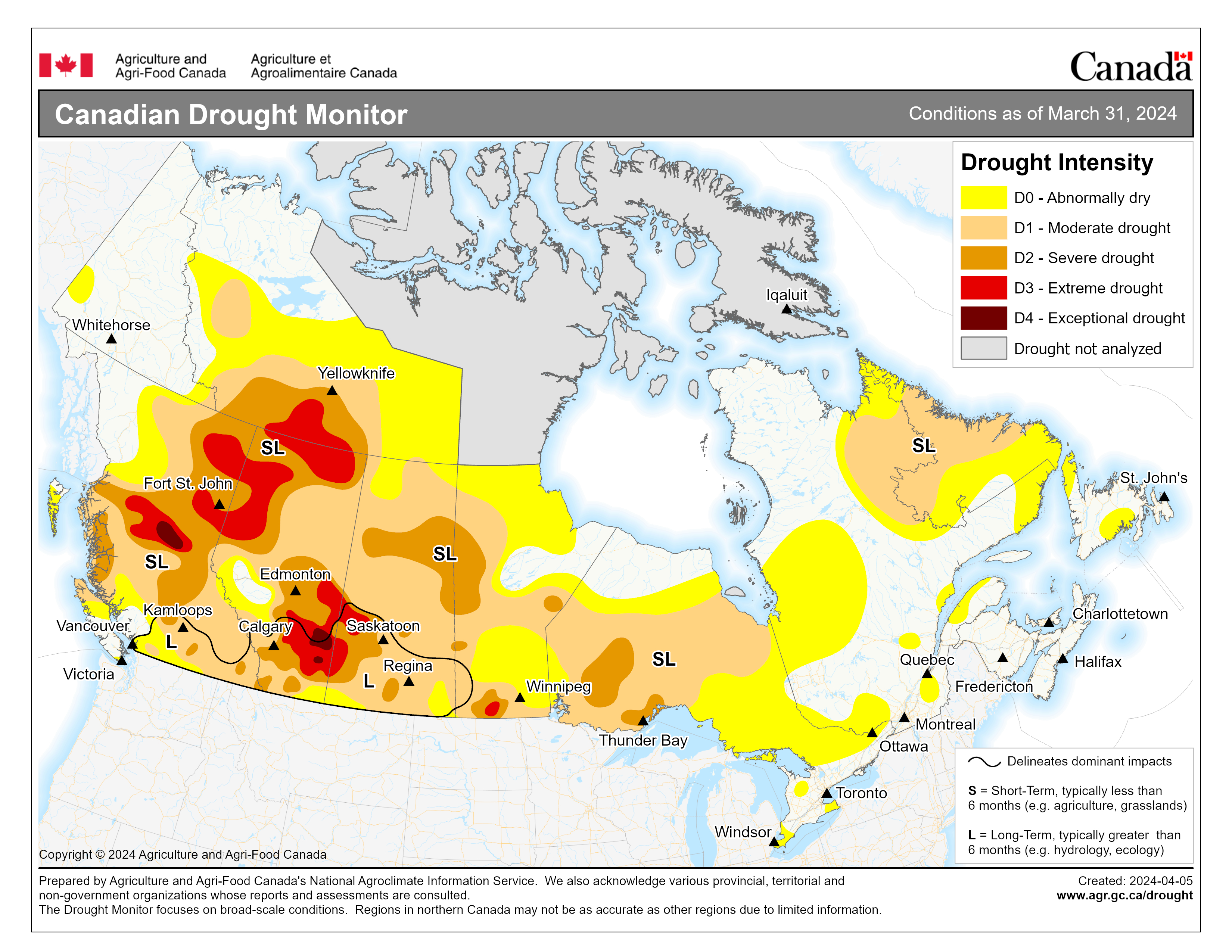
Description of the image above.
The map above shows the extent and severity of drought conditions across Canada. The scale used runs from D0 Abnormally dry to D4 Exceptional drought.
Download a high resolution map and narrative (PDF Version, 773 KB) suitable for printing.
March 2024 Drought Assessment
National Overview
Temperatures across the country in March trended much warmer than normal in Eastern Canada and cooler than normal across the Prairies, with remaining parts of the country seeing temperatures closer to normal. March precipitation was generally wetter in the Atlantic Region which reported more than 200% of normal monthly precipitation. In other parts of the country precipitation was varied with a mixture of slightly above-normal, near-normal or slightly below-normal. However, looking at long-term trends, parts of Alberta and British Columbia continued to report precipitation deficits and impacts from a lack of moisture that remain a concern going into the growing season. Extreme (D3) to Exceptional Drought (D4) remained across south, central and northwestern Alberta, central and northeastern British Columbia and across southern portions of the Northwest Territories. In contrast, drought and Abnormally Dry (D0) conditions improved across parts of Eastern Canada, including the Atlantic provinces and southern parts of Quebec.
At the end of the month, 66% of the country was classified as Abnormally Dry (D0) or in Moderate to Exceptional Drought (D1 to D4), including 82% of the country's agricultural landscape.
Pacific Region (BC)
Drought conditions at the end of March across British Columbia remained nearly identical to the previous month: significant drought concerns persisted in central and northeastern parts of the province while other parts of the province saw either mild drought conditions or an improvement to drought. Most of the province received well below-normal precipitation (less than 60% of normal), with only the extreme southeastern and southwestern corners of British Columbia receiving near-normal monthly precipitation. Mean monthly temperatures were near-normal across the province.
Significant drought concerns remained in central and northwestern parts of British Columbia this month as long-term deficits persisted. Record low flows have been reported near Prince George, for example, as the confluence of the Nechako and Fraser Rivers has nearly dried up with only a handful of puddles remaining. There is little concern for spring flooding given the significantly low river levels. Extreme (D3) to Exceptional Drought (D4) remained across this area due to the continued lack of precipitation and associated impacts.
Further south, recent rains helped to alleviate pockets of Abnormally Dry (D0) conditions around Nanaimo and North Vancouver. Although precipitation trends have been closer to normal in the Okanagan and Kootenay regions, long-term precipitation deficits have not fully diminished, and concern remains over challenges with power generation due to low stream flows. As a result, Moderate (D1) to Severe Drought (D2) remained across the south-central and southeastern regions.
At the end of the month, 85% of the Pacific Region was classified as Abnormally Dry (D0) or in Moderate to Exceptional Drought (D1 to D4), including 95% of the region's agricultural landscape.
Prairie Region (AB, SK, MB)
The Prairies trended drier than normal in March, especially across central Alberta, Saskatchewan, and Peace Region; the exception to this was areas along the Rockies and south towards the Cypress Hills, where a couple of storm systems brought significant precipitation. Despite below-normal temperatures this month across much of the region, mid-month warm temperatures allowed for continued snowmelt. As a result, large stretches of the agricultural region were snow-free by the end of the month.
Much of the precipitation across Alberta this month fell along the Rocky Mountains, across southern agricultural areas, and near Fort McMurray in the province's northeastern corner. However, the Peace Region and the area surrounding Edmonton east towards the Saskatchewan border continued to miss out on much-needed moisture. This concerning trend of significantly below-normal precipitation continued across central and northern parts of the province. These areas have received less than 50% of normal precipitation since the end of September 2023. In addition, despite the improved short-term precipitation in southern Alberta, significant long-term precipitation deficits persisted this month. Extreme (D3) and Exceptional Drought (D4) in southeastern Alberta shrunk slightly but most of the drought areas remained. Concern for water supplies remains as we move into the growing season with many reservoirs reporting significantly lower than normal levels this winter. Much more moisture will be needed to fully amend the significant long-term deficits in southern Alberta. Central Alberta saw a slight improvement to drought between Edmonton and the Peace Region this month, while the Special Areas and areas northward towards Cold Lake saw an expansion of Extreme Drought (D3). Drought across northern Alberta remained unchanged this month, except for a slight expansion of Extreme Drought (D3) along the Alberta-Northwest Territories border.
The majority of agricultural Saskatchewan received near-to above-normal precipitation in March, with central Saskatchewan and the southwest corner of the province receiving 150 to 200% of normal precipitation. Meanwhile, the province's northern region received well-below-normal precipitation this month. Below-normal temperatures were recorded across the province, with temperatures 2 to 4 degrees below normal on average. However, contrary to the overall cooler temperatures, mid-month warm temperatures led to significant snowmelt. Southwestern Saskatchewan saw some drought improvement, including a reduction to Moderate (D1), Severe (D2) and Extreme Drought (D3) conditions, due to storm systems that provided much-needed moisture to the area. However, this area has yet to fully recover from long-term precipitation deficits, meaning that continued precipitation will be needed to further alleviate drought conditions. Drought conditions across the rest of the province remained relatively unchanged, with southeastern and northern regions being closely monitored for the next few months given the transition from winter to spring conditions. Snowfall received during February, March and April is important going into the growing season and will need to be assessed once snowmelt has occurred.
Most of Manitoba received near-normal precipitation in March, except southern Manitoba where below-normal precipitation was recorded. Southeast Manitoba was also slightly drier than normal, recording less than 85% of normal precipitation this month. Mean monthly temperatures were cooler than normal, with eastern regions 2 to 3 degrees below normal. Drought conditions remained relatively unchanged across Southern Manitoba, with Extreme Drought (D3) conditions persisting. Moisture is still locked up within the snowpack, and more time is needed for spring snowmelt to complete in order to assess what improvements to soil moisture and thus, drought conditions, have occurred. Southeastern Manitoba saw slight improvement in drought conditions that led to the reduction of Severe Drought (D2) conditions around Portage La Prairie and from Morden towards Emerson along the Manitoba-U.S. border. Northeastern Manitoba also saw a reduction in Abnormally Dry (D0) conditions from Thompson towards Hudson Bay due to improved long-term precipitation.
At the end of the month, 95% of the Prairie Region was classified as Abnormally Dry (D0) or in Moderate to Exceptional Drought (D1 to D4), including 99% of the region's agricultural landscape.
Central Region (ON, QC)
Parts of central Ontario and southern Quebec received below-normal precipitation in March while the rest of the region received near-to above-normal precipitation. Mean monthly temperatures across the region were warmer than normal, with much of the region seeing temperatures 3 to 5 degrees warmer than normal. Due to the warm and dry weather, pockets of Abnormally Dry (D0) conditions emerged in south and central Ontario and southeastern Quebec. In contrast, significant monthly precipitation of more than 150% of normal allowed for Abnormally Dry (D0) conditions to improve across the Gaspé Peninsula. In northwestern parts of the region, Moderate (D1) and Severe Drought (D2) improved slightly with adequate monthly precipitation and improved long-term moisture. Moderate Drought (D1) also improved across parts of northwestern Ontario given adequate short-term precipitation.
At the end of the month, 55% of the Central Region was classified as Abnormally Dry (D0) or in Moderate to Severe Drought (D1 to D2), including 46% of the region's agricultural landscape.
Atlantic Region (NS, NL, NB, PEI)
The Atlantic Region received well above-normal precipitation in March, upwards of 200 mm or more of total precipitation this month. This consistent and significant moisture has led to the removal of nearly all Abnormally Dry (D0) conditions and Moderate Drought (D1), except for a couple pockets of Abnormally Dry (D0) conditions that remained in southcentral and northern Newfoundland. Despite improved precipitation in the last 3 months, long-term precipitation deficits remained across much of Labrador and as a result, the large pockets of Abnormally Dry (D0) conditions and Moderate Drought (D1) remained this month.
At the end of the month, 56% of the Atlantic Region was classified as Abnormally Dry (D0) or in Moderate Drought (D1).
Northern Region (YK, NWT)
March temperatures were generally warmer than normal across the northern region, particularly in western portions of the Yukon where temperatures were more than 5 degrees above normal. Precipitation was variable this month, with most of the Yukon reporting above-normal precipitation and southern Northwest Territories seeing lower than normal precipitation. Drought changes this month were minimal in the most affected areas due to a persistent lack of moisture in the long term. However, Abnormally Dry (D0) conditions expanded slightly in western Northwest Territories as short-term precipitation deficits emerged and long-term precipitation has been insufficient to overcome deficits from the previous two years.
At the end of the month, 43% of the Northern Region was classified as Abnormally Dry (D0) or in Moderate to Extreme Drought (D1 to D3).
Key Drought Indicators
These are a few of the products that were converged to create this assessment. They may provide additional understanding of drought conditions.
- Short-Term Blended Indicator (PDF)
- Long-Term Blended Indicator (PDF)
- 30-day Precipitation Percentiles (PDF)
- 90-day Precipitation Percentiles (PDF)
- Seasonal Precipitation Percentile (PDF)
- 90-day Standard Precipitation Evapotranspiration Index (PDF)
- 180-day Standard Precipitation Evapotranspiration Index (PDF)
- Palmer Modified Drought Index (PDF)
- Soil Moisture - Percent of Normal (modeled)(PDF)